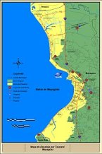
Mayaguez tsunami evacuation map.
Education, Outreach, and Training (EOT)
The EOT initiatives proposed here will be directly carried out by Teng at the University of Hawaii and von Hillebrandt and Mercado at the University of Puerto Rico - Mayaguez. To effectively reduce the loss of life and property due to tsunamis, the population at risk needs to be aware of the hazard and associated risk and be prepared to respond in case of a tsunami. Efforts will be focused on developing greater tsunami awareness on K-12 students, emergency managers and decision makers. Both Hawaii and Puerto Rico have been carrying out EOT initiatives for many years, but through this project many of the existing materials will be updated, placed on line and new resources will be created. Although both Hawaii and Puerto Rico have a history of Tsunami EOT, this will be the first time that they will have a platform for the systematic exchange of the EOT experiences. The results of the experiments will be incorporated to the EOT efforts to reinforce the destructive forces of tsunamis.
EOT in Hawaii
Due to its geographical location at the center of the Pacific Ocean, Hawaii faces a serious threat from tsunamis. After suffering the fatal tsunami attacks from 1949 to the early 1960s, the state of Hawaii has developed and maintained a very good civil defense mitigation plans and helpful public educational activities. These include the publication of inundation maps in phone books, testing of the public siren system at the beginning of each month, and evacuation drills, seminars and presentations to students and citizens during each April which is designated as the Tsunami Awareness Month in Hawaii. At the moment, the state of Hawaii continues to strive for excellence in its civil defense measures and public educational programs for tsunami mitigation. One of the current interests is to update and improve the existing inundation maps as the existing maps were based on 1-D modeling due to the limitation of computer resources at the time the maps were developed. Another is to improve the educational programs, for example, to develop teaching material on tsunamis that can be incorporated into formal science curriculum in schools in Hawaii. There is also a desire for researchers and educators to be able to reach all the residents living in coastal areas, especially those residents with less education and those who live in the coastal areas of high risk. Co-P.I. Teng has conducted research on tsunamis and has been serving on the Tsunami Technical Review Committee for the State Civil Defense since 1999. She and her research assistants have given presentations and showed demos on tsunamis to high school students, their teachers and parents for several years. In addition, she has hosted high school interns in the summer in the hydraulics lab where her group has conducted tsunami simulation and lab experiments. The present proposed research for NEESR can make good contributions to the outreach and educational efforts in Hawaii. The following describes the specific education, outreach and training activities that we propose to carry out during the project period and beyond.
Education and Outreach: The University of Hawaii at Manoa (UH) where Teng teaches is the largest and the only Carnegie Research I University in Hawaii. It has always played an important role in public education and technology transfer through outreach activities in Hawaii. In the present pro-posed project, Teng will first recruit two student assistants (one Ph.D. and one undergraduate) for the project. Since she has also been a team member of the NSF funded Computer Science, Engineering, and Mathematics Scholarships Program (CSEMS, DUE-0220601, funded through the STEM pro-gram) at the University of Hawaii that provides financial support for minority students, she will recruit 2-3 students from the scholarship program and mentor them for tsunami research. She and her students will form a project team to develop preliminary teaching material that will include an inter-active web site, Powerpoint presentation and brochures based on the scientific discoveries from the present research as well as from past existing studies. The team will visit K1-K12 schools to give presentations on tsunami hazards and mitigation measures. During the first year, the visits will be focused on the most populous island Oahu and starting from the second year, the team will also visit schools on all major neighboring islands including Maui, Kauai and the Big Island at least twice a year to each island. Special attention will be given to those schools that are located in high risk coastal areas and schools with a large minority student body including the Kamehameha Schools which educate students of Hawaiian ancestry specifically. After interacting and obtaining feedback from the students and the teachers for three years, we hope to eventually develop suitable course material that science teachers can use in their regular courses so that the topic of tsunami will become a regular part of the science curriculum in Hawaii. The material will be developed in collaboration with Teng's other colleagues at UH with the same interests and will be available for free-download to teachers from the project's web site. The material will be updated from time to time when new information and knowledge becomes available. Besides visiting schools, another outreach effort we plan to carry out is to visit residents living in coastal communities of high risk of tsunami attacks. We are especially interested in reaching those communities with low income and less education and having a large percentage of minority residents such as the Waimanalo community on Oahu. A recent survey done by a social science doctoral student from UH found that there are still a significant percentage of local residents in Hawaii who are not knowledgeable of the tsunami risk and the proper actions to take when a tsunami attacks. In addition, Teng will continue to show demos and presentation to high school students during the College of Engineering's open houses every year and will continue to host high school interns in the summer for tsunami research.
Training: The TSUNAMOS simulation model to be developed in this proposal will become the most advanced tsunami simulation model available. This is because the new model will include a 3-D module that can simulate the vertical variation in water dynamics during the processes of wave break-ing and wave-structure interaction. All existing depth-averaged 2-D models in current applications cannot predict the complex flow features accurately when tsunamis reach the coastal areas especially areas with highly irregular shorelines and rapidly varying topography. This improvement is important to Hawaiian islands as Hawaii's seabed has very steep slopes where the water depth varies rapidly from the land to offshore. It is expected that TSUNAMOS will be able to provide more accurate pre-diction for tsunami inundation and run-up for Hawaii which can help the state develop better inundation maps in the future. In the proposed project, after TSUNAMOS is validated by using the experimental data from the experiments at OSU, Co-P.I. Teng and her students will further validate the model by applying the model to simulate past tsunamis in Hawaii and comparing the predicted results with the field data. Then her team will examine the bathymetry data for Hawaii and use the scientific knowledge obtained from this project to identify coastal areas of high risk. Her team will apply TSUNAMOS to predict the maximum inundation limit for selected high risk areas based on the potential worst tsunami scenarios as case studies. After the validation and case studies, Teng and her assistants will organize workshops both at UH and at civil defense agencies in the state to teach re-searchers and managers how to use the simulation package for tsunami prediction for Hawaii. This can help the local researchers to use the new improved model to produce more accurate inundation maps for the entire state of Hawaii in the future.
EOT in Puerto Rico, the Virgin Islands and Caribbean
Historically Puerto Rico has been affected by destructive tsunamis generated by local earthquakes in 1867 and 1918. Offshore submarine landslides have also been identified, as well as areas for potential landslides, which could be associated with tsunami generation (ten Brink, 2004; Carbo et al, 2005). Regional and distant tsunamis, like the 1755 Lisboa event are also a concern. In response to the great hazard and risk and lack of tsunami awareness, the Puerto Rico Tsunami Warning and Mitigation Program (PRTWMP) was established in 2000 at the University of Puerto Rico at Mayaguez as a joint effort of its Puerto Rico Seismic Network, Department of Marine Science and the Center for Applied Social Research in close collaboration with state, regional and local emergency management agencies. The focus of this program has been inundation modeling, education and outreach and tsunami monitoring, warning and protocols. The results have been a dramatic increase in tsunami awareness and a heightened interest of society to be educated and receive training on this subject. This proposal will have as a foundation this very successful program. Although the Puerto Rico Seismic Network is responsible for earthquake monitoring in the Virgin Islands, due to the source of funding of PRTWMP, our interaction was limited with the Virgin Islands, the Co_PI's will address this situation in the targeted activities.
In the Caribbean, since 1993 initiatives have been underway to develop a Tsunami Warning System for the region. In 1996 the IOCARIBE established its Tsunami Group of Experts. The proposal presented by this group for an IntraAmerica's Sea Tsunami Warning System was approved in 2003 by the Intergovernmental Oceanographic Commission (IOC) of the United Nations Education, Scientific and Cultural Organization (UNESCO). Nevertheless, it has not been until the 2004 Indian Ocean Tsunami that there is the political will and commitment to install such a system (UNESCO, 2005). The IOC convened the first session of the International Co-ordination Group (ICG) for the Tsunami and other Coastal Hazards Warning System for the Caribbean Sea and Adjacent Regions in Barbados, 10-12 January 2006. In this meeting four working groups were established and will be working inter-sessionally on: Coastal Inundation Modeling, Monitoring and Warning, Communication and Dis-semination and Education, Preparedness and Resilience. Mercado and von Hillebrandt chair and co-chair the Modeling and Monitoring and Warning WG's, respectively.
Education and Outreach: In the case of locally generated tsunamis in Puerto Rico, whether earth-quake or landslide induced, the travel time could be so short, a few to tens of minutes, it is imperative that everyone be able to recognize the warning sign of a tsunami and be prepared to respond quickly. For this, education has been recognized as a key element to reduce the loss of life. Mercado and von Hillebrandt have given dozens of talks and organized and participated in workshops on this subject and will continue to do so as part of this project. Nevertheless, during the first year an effort will be made to update the existing Tsunami Powerpoint presentations and brochures for Puerto Rico. A special effort will be made to seek additional audiovisual resources, since these are very effective in presentations and talks. The updated presentations and brochures will be placed online on the web-site of the Puerto Rico Tsunami Warning and Mitigation Program (http://poseidon.uprm.edu), as well as of the Puerto Rico Seismic Network (http://redsismica.uprm.edu). Copies of the PRTWMP 2005 English/Spanish DVD "Tsunamis in Puerto Rico: The Forgotten Danger" will also be made and distributed.
All the materials will also be shared with international organizations like the International Tsunami Information Center, national efforts like the National Tsunami Hazard Mitigation Program Library (http://www.dnr.wa.gov/geology/washbib.htm) and regional centers like the Caribbean tsunami and other coastal hazards information resource center which is proposed to be established as part of the Caribbean ICG. Since the materials developed in Puerto Rico will be in Spanish, contributing these to these depositories will help fill a void in educational materials in this language.
Over the course of the three years the Co-PI's and graduate students will give presentations to schools and community organizations. These presentations will focused on the existing hazard by presenting the tsunami inundation maps, the potential effect of a future tsunami and mitigation measures that must be taken in the home, as well as the workplace. Most of these presentations will be given in Western Puerto Rico where the hazard is greatest and efforts are underway to declare Tsunami Ready Communities. For each activity evaluation materials will be prepared and filled out at every presentation. The feedback of the participants will be used to improve future presentations.
Both Hawaii, Puerto Rico and USVI's economy depend on tourism as an important source of in-come. In Puerto Rico, little work has been done to educate the tourism industry on tsunami prepared-ness. The Co-PI will work with the tourism sector in Puerto Rico and the Virgin Islands to develop a brochure that will be presented to the Association of Hotels and the Convention Bureau and other relevant organizations so that they can reproduce and distribute them in hotels and other tourist facilities. For this, Mercado, von Hillebrandt and Teng will exchange experiences in their corresponding jurisdictions. Presentations or exhibition tables will be arranged for Earth Science Week, Puerto Rico Emergency Management Annual Conference, Annual Meeting of the Association of Private Schools, "Open Houses" of the University of Puerto Rico and other widely attended venues. A peer reviewed article on the outcomes of the education and outreach initiatives in Puerto Rico and the USVI will be submitted for publication. As Chair and Co-Chairs of working groups of the Caribbean ICG, the Co-PIs will use the venue of ICG working group meetings, workshops and sessions to update other colleagues of the region on the activities and materials produced as part of this Project.
Training. Three workshops (one per year) will be held for emergency management and response organizations. These workshops will be focused on creating and updating tsunami evacuation maps and emergency response plans based on the existing tsunami flood maps and training for drills. Given the potentially very short travel times of tsunamis in Puerto Rico, it is very important that emergency and evacuation plans be in place and this is an area that has been identified as a need by the Puerto Rico Tsunami Technical Review Committee and external reviewers (pers. com. GAO, 2005). This is also in line with the goal of certifying communities in Puerto Rico as "Tsunami Ready". During the first year a special workshop will be held for the relevant personnel of the ports authorities, including the US Coast Guard and other coastal critical infrastructure operators (Power Plants). The goal is to increase their tsunami awareness to level they have for hurricanes. This work-shop will focus on the effects of tsunamis in harbors and on coastal infrastructure and tsunami hazard mitigation aspects (tsunami flood maps, travel times, ship and personnel response measures).
During the second year a "train the trainers" workshop will be given in the Virgin Islands in co-ordination with the University of the Virgin Islands and the Virgin Islands Territorial Emergency Management Agency. A copy of the presentations updated according to the feedback received in the workshop will be made available to all participants so they can continue carrying out this work. In the third year a tsunami and coastal engineering seminar will be held for engineers, elected officials, decision makers and emergency managers will be held in Mayaguez, Puerto Rico. The effectiveness and feedback of the educational and outreach efforts and the results of the modeling and wave tank will be presented and discussed. The objective of this seminar will be to delineate a strategy for the construction of a tsunami resilient society, by improving planning, land use management and construction practices in coastal areas. For this seminar, the PI, Co-PI's and experts from the Caribbean will participate.